RunFlow()
una.RunFlow() computes per-edge pedestrian or bicycle flows across
the network, given origin and destination point layers. It is UNA’s
customized betweenness-centrality analysis, tuned specifically for active
mobility modeling.
What it does
Conceptually, RunFlow():
Loads network, origins, destinations, and (optionally) observer and obstacle layers.
For each origin, identifies the set of destinations within
settings_reference:search_radius.Distributes each origin’s trip generation across those destinations using a Huff-style gravity model (when
settings_reference:flow_destination_weights= True).For each origin-destination pair, enumerates K alternative paths using Plateau’s penalty method (up to
settings_reference:flow_n_alternatives).Splits the trip between those alternatives (weighted by
settings_reference:flow_path_detour_penaltyand the detour envelope).Accumulates every trip’s contribution onto each edge it traverses, producing a per-edge flow value.
Exports the per-edge flow (and optionally per-node flow, observer counters, and obstacle usage) as a GeoDataFrame.
The engine handles turn-aware routing, elevation penalties, obstacle costs, per-origin destination assignment, and directional (AB/BA) flow tracking — all controllable through settings.
Choosing an engine
RunFlow() dispatches to one of two flow engines based on
settings_reference:flow_engine:
Engine |
How it routes |
When to use |
|---|---|---|
|
Distributes each trip across the OD pair’s full gradient-overlap envelope in one pass — no path enumeration. |
Large and state-wide runs; whenever flow should spread over the complete envelope of viable streets. Turns and assigned routing not yet supported. |
|
Enumerates up to K discrete alternative paths per OD pair (Plateau’s penalty method) and splits the trip among them. |
Path-level fidelity; turn-aware routing; assigned routing; route-alternatives export. |
Both engines populate the same result arrays and produce the same
output files, so switching engines is a one-line change. Within the
k_alternatives engine, turn-aware routing switches on internally
when settings_reference:turns = True; there is no separate
class name to worry about. See K-alternative paths (Plateau’s method) and
Aggregate flow (gradient-overlap method) for the math behind each.
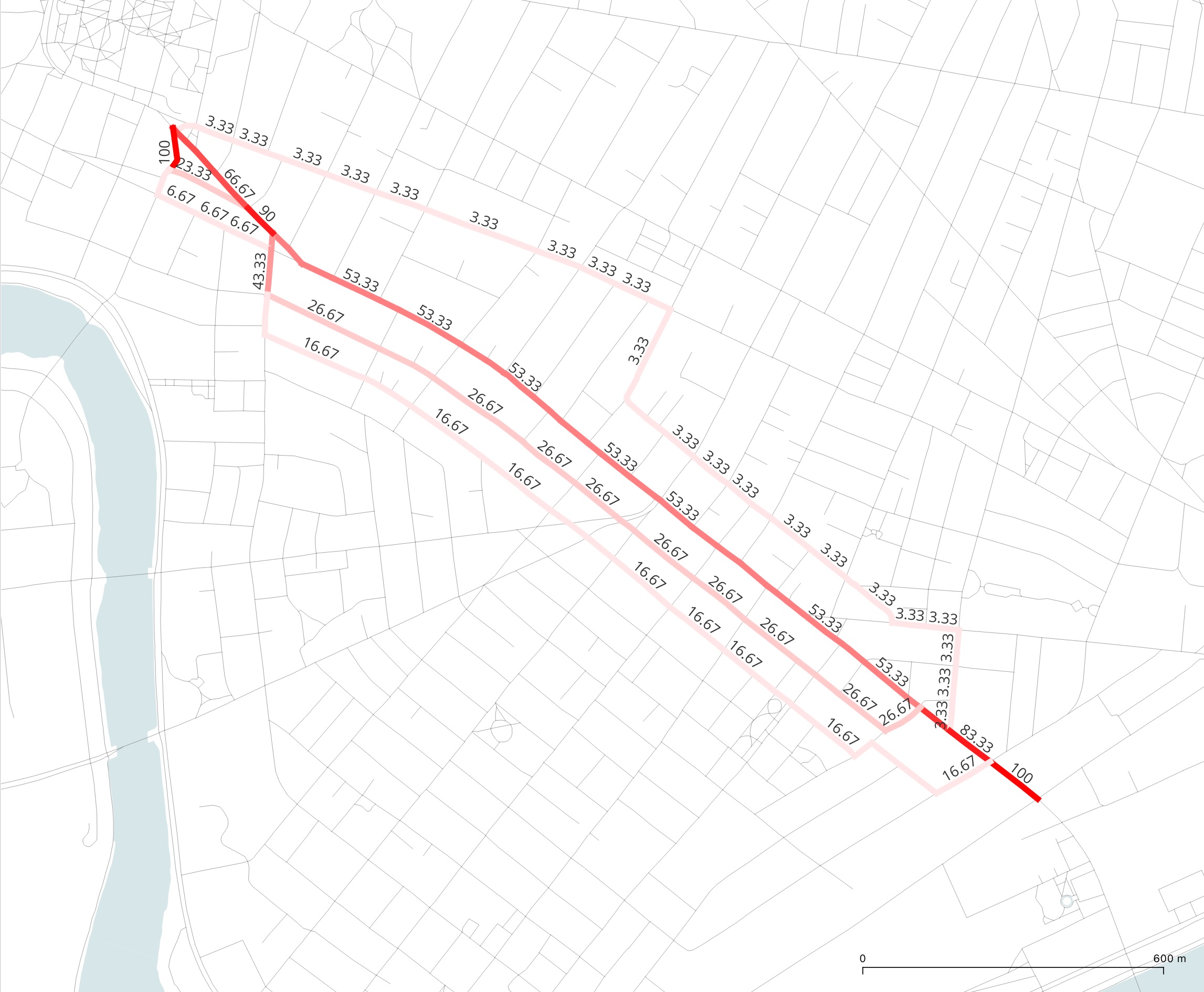
The same origin–destination pair (MIT SAP → Harvard Housing Center, origin weight 100) through both engines, with identical settings:
|

|
K-alternative flow, detour ratio 1.2 — trips split across discrete alternative paths. |
Aggregate flow, detour ratio 1.2 — trips spread across the full detour envelope. |
Minimum required settings
The three data layers plus a search radius:
una.settings.data_folder       = r"Boston"
una.settings.network_file      = "20260703_PercLenNetwork_InnerCore.geojson"
una.settings.origins_file      = "Cambridge_building_centroids_pop2020.geojson"
una.settings.destinations_file = "MA_bus_stops.geojson"
una.settings.search_radius     = 500

una.RunFlow()
Every other flow parameter has a sensible default: exponential decay
turned on, detour ratio 1.05, ten alternatives per OD pair, origin and
destination weights read from the "Count" sentinel column.
Key parameters to think about
For a realistic pedestrian-flow model, the parameters that most affect the shape of the output:
Setting |
Effect |
|---|---|
|
How much longer than shortest an “acceptable” alternative can be.
|
|
|
|
Cap on paths per OD pair. |
|
|
|
Turn-aware routing. 2–4× slower but usually essential for a defensible model. |
|
Uphill penalty. Requires 3D LineStrings in the network file. |
See K-alternative paths (Plateau’s method) for the math behind path enumeration, and Gravity and decay models for the trip generation math.
Optional inputs
Observer points. Passive counters that report the flow passing
through them, without influencing routing. Load via
settings_reference:observer_points_file. See
Observers and obstacles.
Obstacle points. Cost-adding penalties on specific edges or nodes.
Load via settings_reference:obstacle_points_file. Affects
routing decisions. See Observers and obstacles.
Per-origin destination assignment. When both
settings_reference:origin_destination_id_column and
settings_reference:destination_id_column are set, each origin
routes only to destinations whose ID matches — useful for scenarios
like “route each school only to bus stops in the same district.”
What gets exported
Output lands in <data_folder>/Results/flow_<timestamp>/ (unless
overridden). The primary files:
File |
Contents |
|---|---|
|
Per-edge flow — one row per network edge, columns for total
flow and (when
|
|
Per-node flow, written when
|
|
Observer point flow counters — one row per observer with
|
|
Obstacle hit counters — one row per obstacle with |
|
Per-destination list of contributing origins. Written when
|
|
Complete generated route geometries — one row per alternative
path. Written when
|
Exporting route alternatives
For route-choice studies you often need the routes themselves — not betweenness estimates — so modeled alternatives can be compared against externally observed routes from GPS traces or surveys. Two settings turn this on:
una.settings.flow_route_id_column = "route_id"   # column in BOTH origin and destination files
una.settings.flow_output_routes   = True

una.settings.flow_path_detour_penalty = "exponential"
una.settings.flow_route_enumeration_beta = 0.05

una.RunFlow()
Prepare each observed route’s origin and destination point externally,
give both the same route_id value (text or numeric), and UNA
generates the K alternatives per pair — exported as
<file_name>_routes.geojson / .feather / .csv with one row
per alternative:
Column |
Contents |
|---|---|
|
The value shared by the origin and destination — joins the generated alternatives back to the observed route. |
|
Endpoints of the OD pair. |
|
1 = shortest path, 2..K = successive alternatives. |
|
Actual (un-penalized) path cost, connector partials included. |
|
The network edge ids composing the route — space-separated, handy for map-matching against GPS traces. |
|
Merged LineString of the route’s edges. |
Notes: the number of alternatives per pair is controlled by
settings_reference:flow_n_alternatives and the detour
envelope; route geometries include the full first/last snap edges (they
are not trimmed at the exact origin/destination snap points); and the
normal flow/betweenness outputs are still written alongside. Requires
flow_engine = "k_alternatives".
Where results also live
Numeric outputs are also accessible on the una.flow instance:
una.RunFlow()
edge_flow_total = una.flow.edge_flow
observer_totals = una.flow.observer_flow_total
Handy for plotting or further pandas manipulation without re-reading the file.
Runtime and calibration tips
Prototype cheap, then commit. For iteration, keep turns = False,
elevation = False, flow_detour_ratio = 1.05, and
flow_n_alternatives = 10. A 10,000-origin run finishes in seconds.
Turn on the expensive knobs for the final production run.
Scale expectations. For pedestrian analyses on a city-sized network:
100 origins × 500 destinations × K=10 → seconds.
10,000 origins × 500 destinations × K=10 → 1–3 minutes.
20,000 origins × 500 destinations × K=50 + turns + elevation → 10–30 minutes.
Calibrate against counts if you can. UNA’s flow output is descriptive on its own but becomes predictive when you fit its edge-by-edge output to real pedestrian counts (from cameras, intercept surveys, automated counters). Once fitted, the model answers “what if” scenarios — the point of doing the analysis at all.
Example — homes to bus stops in Cambridge
from urban_network_analysis import UNA
una = UNA()

una.settings.data_folder       = r"Boston"
una.settings.network_file      = "20260703_PercLenNetwork_InnerCore.geojson"
una.settings.origins_file      = "Cambridge_building_centroids_pop2020.geojson"
una.settings.destinations_file = "MA_bus_stops.geojson"

una.settings.search_radius             = 500
una.settings.origin_weight_column      = "pop2020"
una.settings.destination_weight_column = "weekly_departures"

una.settings.flow_decay                = True
una.settings.flow_decay_curve          = "exponential"
una.settings.gravity_beta              = 0.001

una.settings.flow_detour_ratio         = 1.15
una.settings.flow_detour_mode          = "min"
una.settings.flow_n_alternatives       = 30

una.RunFlow()
Produces per-edge foot-traffic estimates for every residential-to-transit trip in Cambridge, with the Huff destination-choice model splitting each building’s trips across nearby stops in proportion to daily departures.
Next steps
RunAccessibility() — per-origin scores instead of per-edge flow.
Project workflow — RunBatch() — automate multiple flow scenarios from a CSV.
Observers and obstacles — passive counters and cost-penalty points.
Tutorial 3 — Foot-traffic flow analysis in Cambridge — ten-step walkthrough with worked examples and figures.
K-alternative paths (Plateau’s method) — Plateau’s penalty method explained.
Aggregate flow (gradient-overlap method) — the scalable gradient-overlap engine explained.